We use cookies to make website more useful for you.
Ok
Turn your UAV aerial data into orthophotomosaic, DSM and point cloud in a couple of clicks in your browser.
Attractor is a professional web service for photogrammetric processing of UAV data without special knowledge
scanned and processed by the team during development
500 +
projects
hectare scanned while finetuning the service
1 000 000 +
service was created by specialists in geodesy, cartography and aerial photography
year of experience
10 +
01
Automatic processing of aerial survey data without advanced software and expensive servers.
Obtain results in 1 hour without advanced PC
High data accuracy
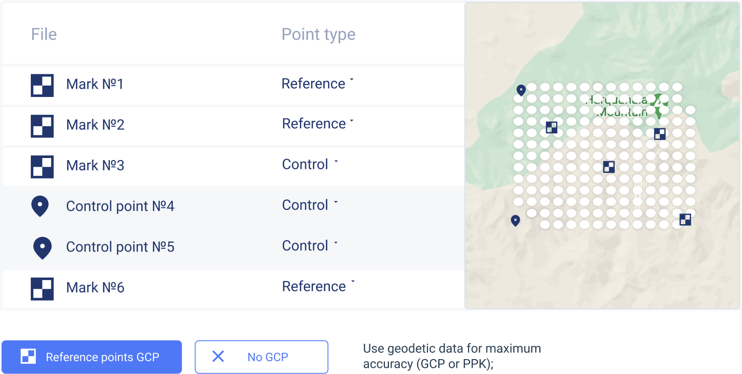
Built-in GCP and PPK functionality to reach geodetic accuracy.
02
Photogrammetry easy and for all for
Convenient API for integration with current corporate software.
03
Transparent pricing: pay per hectare
Convenient price calculetion based on the area under survey.
04
How Attractor works
STEP 01
We support various cameras and photos in .jpeg or .tiff.
Collect UAV data

STEP 02
Upload up to 10,000 images without special hardware or software.
Upload and process

STEP 03
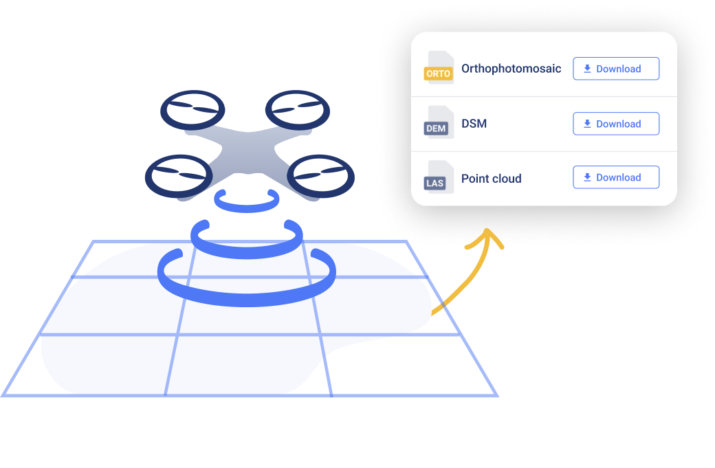
Download output data in the format you need and use it in existing tasks
Download the result
Orthophotoplan
Our data compression algorithms allow to save up to 10x data space compared to conventional protogrammetric processing engines without loss of quality.
Surface
Use the maximum quality settings to obtain best-in-class result with a 800 dots per 1 m² density.
Point clouds
Vizualize point clouds online in your browser. Attractor will show up to 10 billion points on any computer with a configurable display density.
Output: photogrammetry has never been so easy
Processed data fits


Photo upload

Upload up to 10,000 images without special software. Attractor converts photos into digital models of your object. Processing of most surveys takes up to 1 hour, after which the output will be online and available for download in your account.
Data processing
Attractor supports any cameras and any photos in .jpeg or .tiff formats. To get the best result, use geodetic data for maximum accuracy.
Downloading and using output data
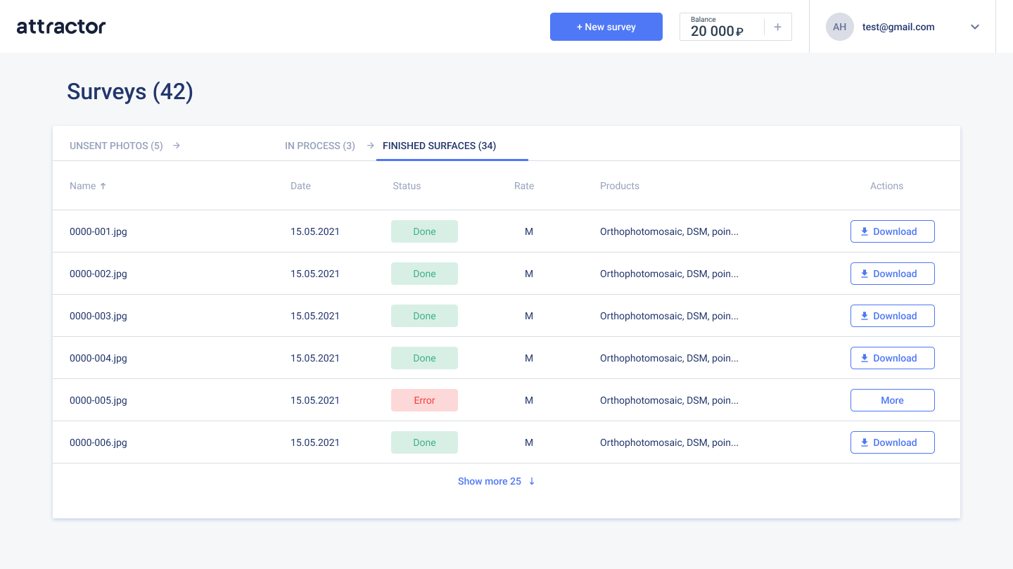
Download the data in the preferred format and integrate it into your existing workflows.

built-in resumable file uploads functionality for unstable internet connections.

upload data even with weak internet connection;

Upload data directly in your browser;
built-in check of your survey data for errors and torn tacks;

select output data – orthophotoplan, surface, point cloud, or all at once.
choose preferred data quality: medium, high, very high;
Use geodetic data for maximum accuracy (GCP or PPK);
download output data and use it in third-party GIS and CAD programs.
Use Attractor as a single repository for processing results;
online vizualization of any data array;
Aerial mapping has never been so easy. Attractor is designed to provide best-in-class results for any equipment ranging from affordable DJI Mini series up to industrial-class DJI Matrice 300RTK.
GCP
Attractor supports ground markers and ground control points.
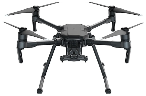
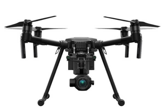
Recommended UAVs
ENTRY LEVEL

PPK
Attractor can process data from the geodesic log to achieve maximum accuracy.

Plain processing
Quick-and-easy processing and high-quality result for tasks that do not require geodetic accuracy.
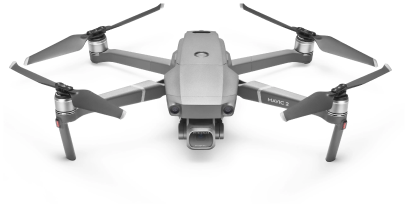
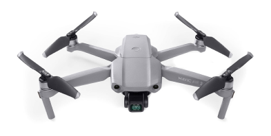
ADVANCED
ENTERPRISE
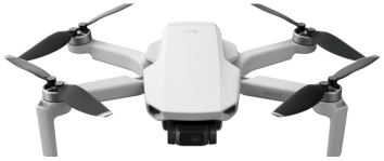
DJI Mini 2
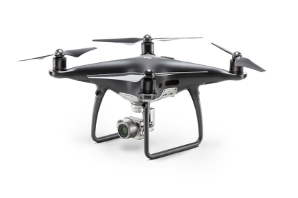
Phantom 4 PRO
Mavic 2 Pro
Mavic Air 2
Matrice 200 / 210 / 300
You can use any drone from entry to industrial level

For UAV mapping beginners
For industry professionals
Enterprise users
Attractor is a one-fits-all solution
in case you don't have your own computing power and software;
for occasional surveys or one-time mapping tasks
in case you are making your first steps in UAV pamming and you are now sure how to get a high-quality result.
you are able to process data, but you lack computational power to handle big-ticket contract;
if you need to store big data in one place with fast and convenient access to evaluate results
if you need to transmit extensive processing results to your customer.
If you need to adopt a technology (with an option of optimizing your staff);
if one of the goals is to upscale aerial survey technology in-house;
If you need to mitigate human factor;
you are in need of control the processing quality result at every stage anywhere.
We take the security of our customers' data seriously. Therefore, we have set up a reliable storage together with our processing cluster in a certifiec TIER3 data centers (data center security level suitable for processing personal data and banking transactions) and are constantly expanding its capabilities. Our servers are continuously patched with the latest security updates in order to ensures the security and confidentiality of any customer data.
Keep your data in a secure location
Data security in Attractor
Transparent pricing:
photogrammetry starting from $149
Clear and intuitive rates depending on the area of your survey. Pay for hectares, don't mess with the number of photos.
Processing in Attractor is charged on a per flight basis. The cost of processing depends on the area (in hectares) of the surveyed are and the size of the photos in storage.
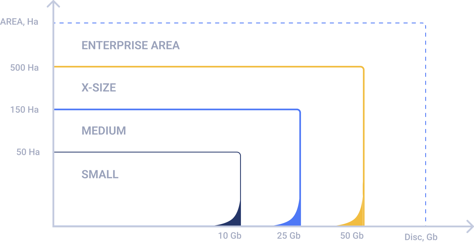


Upload data: up to 10 Gb
Area: up to 50 Ha
Suitable for most private and residential development projects, landfills.
$149
SMALL
MEDIUM
$299
Suitable for civil engineering, warehouses and small quarries.
Area: 50-150 Ha
Upload data: 25 Gb
X-SIZE
$459
Suitable for large construction sites, industrial construction projects and mining.
Area: 150-200 Ha
Upload data: 50 Gb
ENTERTPRISE
Individual
Suitable for objects of regional and federal scale, multi-object projects.
Area: 500+ Ha
Upload data: 50+ Gb
Transparent pricing:
photogrammetry starting from $149
Clear and intuitive rates depending on the area of your survey. Pay for hectares, don't mess with the number of photos.
Processing in Attractor is charged on a per flight basis. The cost of processing depends on the area (in hectares) of the surveyed are and the size of the photos in storage.
Upload data: up to 10 Gb
Area: up to 50 Ha
Suitable for most private and residential development projects, landfills.
$149
SMALL
MEDIUM
$299
Suitable for civil engineering, warehouses and small quarries.
Area: 50-150 Ha
Upload data: 25 Gb
X-SIZE
$459
Suitable for large construction sites, industrial construction projects and mining.
Area: 150-200 Ha
Upload data: 50 Gb
ENTERTPRISE
Individual
Suitable for objects of regional and federal scale, multi-object projects.
Area: 500+ Ha
Upload data: 50+ Gb
Start with trial processing
Apply for trial and get free processing sessions

Get an access to Attactor demo for 14 calendar days to estimate all service options
Demo is free of charge and lasts within 14 calendar days. Fill in forms with appropriate data. Our manager will contact you asap and activate the access.
Your data will not be shared with third parties
ENTERPRISE
If you want to negotiate special offer, fill in forms with appropriate data. Our manager will contact you asap and activate the access.
Your data will not be shared with third parties